DIGITAL SURVEY REPORT
5OCT20 - THAILAND'S GOLDEN CATS
Location(s):
Khao Yai National Park - Nakorn Nayok - Thap Lan National Park - Prachinburi
Huay Kha Kheng Wildlife Sanctuary - Uthai Thani - Thung Naresuan Sanctuary - Tak
Client: Lion Mountain Media (South Africa), National Geographic (United States)


HUAY KHA KHENG WILDLIFE SANCTUARY


OVERVIEW
Huey Kha Kheng Wildlife Sanctuary and Thung Yai Naresuan Wildlife Sanctuary were recommended to us as the two places with the highest level of protection and conservation for wildlife in Thailand, and also likely to have the most diverse number of species. This place is overall very remote, very quiet and very restricted. As you can see from the map below, there are hardly any roads leading into the jungle, the terrain is very hilly, and most of the trail is off-road.
PRECISE CO-ORDINATES: 15.6055418,99.3200757 (Use the Main Entrance)
TRAVEL TIME FROM BANGKOK = 4.35 hrs (312 km)
TRAVEL TIME FROM THAP LAN NATIONAL PARK = 6.20 hrs (435 km)
AREA = 2780 km²

WILDLIFE
The officials have a very comprehensive tracking and knowledge about the various animals and zones inside the forest. They were very helpful and would be willing to assist us in any way possible. These two areas have up to 130 species of wildlife, and 6 endangered and protected species, including all species of wild cats.


ACCOMMODATION AREA
There is no accommodation available inside the park, therefore we will have to lodge in one of the places outside of the park.
CELLULAR GSM COVERAGE AREA
Below are charts of Cellular (GSM, 3G, LTE) coverage areas for the two major carriers in Thailand, TrueMove and AIS. Unfortunately, it seems there will be no cellphone coverage in many areas inside the jungle for both Huey Kha Kheng and Thung Naresuan. So perhaps, you may consider adding a Satellite Phone into the main budget.


ELEVATION MAP
This is the elevation map for both the sanctuaries.

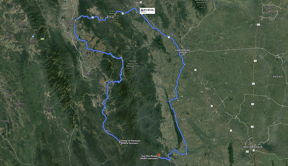
TRAVEL FROM HUAY KHA KHENG TO THUNG YAI NARESUAN
The biggest surprise of this trip, we found out, and we didn't account for in our production schedule as well, is the apparent travel time from Huay Kha Kheng to Thung Yai Naresuan. Even though both the wildlife sanctuaries are next to each other on the map, and it is on continuous forest area, however, there is no road directly between the two as it is separated by long mountain range in the middle. Therefore, it means that after finishing the shoot at Huay Kha Kheng, it involves an 8-hour drive around the mountain ranges in order to circle back to Thung Yai Naresuan.
THUNG YAI NARESUAN WILDLIFE SACTUARY
Our plan was to travel to Thung Yai Naresuan in the early morning, but due to heavy rainfall and mudslides in the area, we couldn't make our trip there as planned. Therefore we requested the authorities if we could submit our application at the Huey Kha Kheng office instead and they agreed. So we did that and returned home. In terms of overall details, Thung Naresuan will be very similar to Huay Kha Kheng.